Friday, December 30, 2016

Saadani National Park

Zaraninge Forest
The cornerstone of our Christmas holiday was a trip to Saadani National Park, mainly to see the supposedly best conserved patch of coastal forest in Tanzania. We took some trips to other non-national park coastal forests and we were a bit disappointed in what we saw. We hadn't heard many glowing reviews of Saadani and due to it's relatively new gazetting (created in 2005) we didn't expect the fantastic wildlife of the northern parks since it was cobbled together from former hunting areas giving it an odd feel with a village and salt production facility in the heart of the park.

Our goal was to camp and hike in Zaraninge Forest though information on the internet and from friends was very sparse. When we got to the park headquarters we were told that road and campsite were closed. They also said they no longer do hikes in the area and that all the trails were closed. I persisted a bit and they finally relented saying that we could try but we wouldn't get our money back if the "special" campsite there was inaccessible. Funnily enough, it is $15 more to camp at the "special" campsites in the national parks here, which don't have any facilities. I was determined to reach the forest (or at least try) but we were a bit disappointed at the news we received. I was delighted to hear we could do a river cruise and that we could do it immediately before we tried to head to the forest (it was on the way).

To access the river you have to drive through a salt pan, which is unsightly though interesting to see. We were the only two people on the boat and although the wildlife was sparse (we saw a few hippos), it was cool to go out to the mouth of the river and see the mangroves. Our boat driver received a phone call and the trip was cut short because another group had come. It was a pretty poor value for one hour on the boat, though the timing would have probably been better in the morning or evening if we wanted to see wildlife other than birds.

After the boat cruise we made our way to the forest. We literally saw more cattle than any other wildlife (which actually, we didn't see any other mammals in this part of the park) and the drive took us through several villages. We were getting a bit nervous and feeling somewhat lost when we came upon an old WWF office. WWF had previously managed the Zaraninge Forest before it became part of the park. The ranger there told us we were almost there and gave us some direction.

When we finally reached the turnoff, it appeared our luck had changed. The forest was beautiful and undisturbed. However, the road was cluttered with tree falls and at one point I had to spend about a half hour cutting through a large branch with a machete. We also had to move a giant log in order for us to pass another very narrow section before reaching an absolutely stunning campsite.

The area around the campsite was very cool with massive wetlands (though quite dry this time of year) within a five minute walk. There was also a network of signed trails in the area but none of them led further than a 15 minute walk before being bushed out. It was quite disappointing that the area was not being managed though it was positive that there didn't seem to be any signs of resource extraction. The campsite was quiet and isolated and we enjoyed it immensely.

On the way out we stopped at the main beach campsite that was packed with day trippers from Dar es Salaam. We didn't see any more wildlife on our way out and although the trip was arduous we agreed it was worth it, though doubtful we would return again. We wouldn't recommend visiting the park unless you were particularly interested in the coastal forests.

Chopping those trees

Ana checking out the mangroves

Typical Saadani landscape

River campsite

The beginning of Zaraninge Forest

The wetlands in Zaraninge Forest

Campsite

An awesome bug at night

Zaraninge Forest

Beach campsite


Tanga Coast: Trip III

We love going to the Tanga coast (Trip I, Trip II) and with the extended Christmas break we could go to our usual spot at Peponi as well as explore some other places along the coastline.

We stayed at a place called Barry's Beach Resort close to Mkwaja, the closest village outside of Saadani National Park. It's located on a very deserted beach and the property is the result of some serious investment though it was a little too nice and sanitized for our style. Still, it was cool to see a different part of the Tanga coast and it had camping facilities.

We later explored some of the coast around Pangani, including a trip up the Pangani River. There was one really nice deserted beach and the Pangani River provided an interesting excursion with a road that bisects a fantastic mangrove forest. There really aren't any great touristic features but we always love to "fill in the map" and see what is there.

Our trip finished at Peponi, which was awesome as usual. They have such a fantastic environment that caters to both backpackers and families and it provided a great base to explore the coastal forests and surrounding environment. The only downside of the trip occurred when I dropped our camera in the ocean. Luckily we have a backup camera but I loved our new camera so it's a tough loss. I wasn't even inebriated or anything and I even had the camera strapped around my arm. It just slid off as I tried to climb into a boat when we were bird watching. Too bad, but it still can't spoil the overall trip!

The beach close to 

Ana checking out some birds at Barry's. 
The view from Barry's patio.

Pangani River
A beach just outside of Pangani town. 

Peponi sunrise. 

Ana checking out some birds. 

A cool fish. 

Relaxing birding walk along the tide pools in the morning. 

Coastal Forests in Tanga

View of the landscape
We have long been intrigued by the unique habitat of coastal forests, which stretch from Mozambique up through Kenya. A dedicated conservation site, "Coastal Forests of Kenya and Tanzania", gives the following info:

The Coastal Forests of East Africa are a globally recognised area of great biological importance and diversity. Many species are endemic to these forests, for example 44% of plants are endemic to the coastal forests and 40% of plant genera are confined to a single forest patch. Forests only 100 km apart may have an 80% difference in their plant species.

Unfortunately, the majority of the original coastal forests have been decimated. Of the original 291,250 km2, only 10 % (29,125 km2) of natural vegetation remains. This is distributed across more than 400 forest fragments which, ecologically speaking, leads to a slow death since there are no corridors for wildlife. Making matters worse, the forest fragments are typically completely un-managed and subject to intense local use for charcoal, timber, and other products. In light of all this, we wanted to see what remains before it is too late!

Information is extremely sparse so we relied on forestry surveys and google maps to identify forest reserves close to Pangani in Tanga Region. We settled on Msumbugwe and Kibubu Forest Reserves, the former a bit south of the Pangani River and the latter a bit north. We also visited Zaraninge forest, which is located in the more formally protected Saadani National Park, written about in this blog entry.

The Msumbugwe forest was a massive disappointment. Although the area shows up as very green on google maps, it is evident the forest has been cleared of big trees and what remains is a dry and hot area filled with shrubs.  There was a large and well maintained road bisecting the reserve with multiple trails leading to tree falls. We walked on several of these trails but after an hour or so, we turned back without having seen much of anything.

We later went to Kibubu Forest Reserve, which is a former WWF managed site. WWF had a big investment in coastal forests but has since removed themselves from the project in the Tanga Region. Kibubu Forest had some nice patches of forest but appeared to have a much more formalized charcoal operation. Huge areas were clear cut with massive burning pits for charcoal. Once again there was an extensive network of trails with evidence of firewood gathering and charcoal burning.

In Kibubu we saw a motorcycle with a passenger come and turn around as soon as they saw our car. When we exited we were met by a group of people that said they saw our car come in and they inquired what we were doing in the forest. We are technically supposed to get a permit to enter the forest but it was obvious that the group was anxious. It probably didn't help we have a WWF sticker on our car, which made them even more nervous. We had a tense but cordial conversation where they said they had a permit to take charcoal while I commented that the cutting seemed like too much.

Having worked with communities bordering conservation areas, I truly struggle with these types of situations. The forests provide income opportunities to people without an education or other economic opportunities. Absent of income generating opportunities or incentives to not cut the forest, what is to be expected? I don't think for a second that I would act differently in their situation and thinking about conservation in general is something that is afforded to those who have their basic needs taken care of. It is why I believe that education and economic development (and possibly carbon credits) are the only ways to conserve, not just gazetting an area and policing it. It is a shame that they are left in a kind of no mans land whereby locals are in fear of extracting and there are no land use management plans or things of that nature. I have written to WWF to try to understand why they pulled out of that area but the lack of information on the internet leads me to believe it may be opening pandoras box....

Charcoal pit

Big clear cut opening in the forest

Hiking!

A very cool tree; dark smooth wood with a paper like bark and spines


Monday, December 19, 2016

Tarangire National Park: Trip III

Ol Donyo Sambaa in back of the elephants grazing the swamp. 
This past weekend we took our first "self-guided" safari to Tarangire National Park (Trip I). We had visited there twice before, both occasions when our respective families visited and did a long safari. However, the normal safari route only schedules a half day in Tarangire so we were curious to see what else the park had to offer.

We left on Friday evening and drove straight to Makuyuni, a dilapidated junction town that sits on the main highway from Arusha. I say we drove straight but we actually spent over an hour in traffic in Arusha. They are widening the highway there and we also ran into some esteemed government representatives (rumor had it the prime minister was there). When big wigs from the government come through cities, the traffic police close off the roads for about a half hour. Because of the construction and lack of direction (as well as lack of compliance following rules), we somehow ended up in the middle of six lanes of standstill traffic. We thought we were in serious trouble when a mini bus next to us started to offload passengers and goods but eventually we made it through.

Without traffic the drive to Makuyuni was only about 2 1/2 hours, with another half hour to the park. We were able to find a very decent local guesthouse for $15.

The next morning we headed out early and started to explore the park. Because most tourists come in the afternoon, we basically had the park to ourselves the entire morning. We enjoyed driving along the river taking numerous "river circuits" that looped around back to the main road. The morning was overcast, which was nice, and we saw huge herds of elephants, wildebeests, buffalo and zebra. The short rains must have passed not long ago because the entire landscape was green.

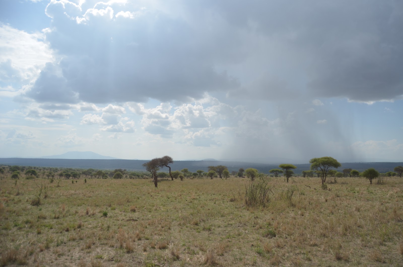
Around noon we reached a drier part of the park as we continued to head south. I wanted to reach a place called Silale Swamp but the map we had was not too good and gauging how long it would take to drive is not easy on poor roads. Compounding confusion was the fact that the park is signed, but a bit inconsistently and lacking details such as how many kilometers remained. As we hit the dry patch the wildlife decreased and the sun broke through, changing the cool breezy drive with several stops for wildlife to a hot and speedy cruise as I tried to get us to the swamp.

We got to a junction that had a sign towards "Silale Swamp Picnic Area" and one towards "Silale Swamp". We turned towards Silale Swamp and immediately the road began to narrow from disuse. There was suddenly a bit of animal life but the elephants we encountered were hostile, likely a result of their VERY small babies and also their negative experiences with poachers and those driving them away when they raid crops. We've seen skittish elephants before and it always gives us an appreciation for the tame ones that we do see. A scared elephant is no fun to see, especially when it's you as a human that is scaring them.

We finally decided we'd gone far enough and turned around. Our spirits were a little low and it was past lunchtime but I told Ana that we'd try to go to the Silale Swamp Viewpoint and if we didn't reach in 20 minutes we'd just eat lunch at the side of the road. Luckily, we reached Silale Swamp (+ the picnic area) in about 10 minutes and were greeted with an unbelievably picturesque view. We set up under a tree and watched the wildlife for about an hour before packing up and heading back.

On our way back we met a big rainstorm that was a welcome relief to the dry conditions we met in the south of the park. We encountered a big herd of elephants crossing the road and I let them pass about 10-15 meters ahead of us. They had some tiny tiny elephants with them and the last elephant, a big bull, was not too happy with our positioning. He kind of turned and jogged backwards facing us, and then trumpeted a warning shot. My heart just about dropped out of my pants as I instinctively shifted the car into reverse and floored it.  Just a warning, nothing serious, but I learned something about elephants and space!

A lone male in the morning digging for some minerals. 


Very green landscape. 

Approaching the swamp. You can see how dry it is before the swamp. 

It was a nice view

Ana checking out some birds. 

I love seeing sheets of rain across the plains. 
Passed a bunch of giraffes on the way out. Check out the one hiding behind the trees. 

Elephants in the rain. 

Monday, December 12, 2016

Shagayu Forest Reserve

Beginning our hike amongst the clouds.
The unique rainforest habitats in the Eastern Arc Mountains are one of our favorite places to visit in Tanzania. With dozens of forest reserves scattered anywhere from 1 1/2 to 8 hours from us, we've spent the last few years exploring as many of the pockets of forests as possible. This weekend we went to the Shagayu Forest Reserve in the West Usambara Mountains.

It took us about seven hours from Moshi to reach our main base outside the forest. We had arranged with two local guides to hike to the peak and camp, and descend the following day. We were a little concerned because from where we stayed in Mambo, we couldn't see the forest, rather we could only see clear cut areas for agricultures or pine plantations. We were also concerned because the area appeared to have their short rainy season at this time and combined with the elevation, it was quite wet! Still, we prepared the best we could and we've had many hikes in the Eastern Arcs with a bit of rain. After all, you can't expect to visit a rainforest without, rain?

When we left Mambo in the morning our spirits were high and our backpacks were loaded. We walked through the village and cut up through a pine plantation at which point we could see the forest. After about an hour we reached the forest reserve and started our trek. One of the things we love about montane rainforest is the fact that small peak receives different amounts of moisture and sun and provides a variety of habitats as you walk.

We reached a rock face for lunch and it provided an amazing view over some forest covered mountains with the plains in the far distance. It was awesome to get a view of the forest and we were told the peak doesn't actually have a very nice view so it was the best vista we would get. After a nice lunch it began to rain and our pace quickened so we could reach the top. It started as a classic rainforest misty rain and then quickly evolved into a downpour. Within 10 seconds we were soaked to the bone. We pressed on for a few more hours and finally reached the  peak. There was a large rock face that created a mini shelter but we were also pleased to see the rain had stopped on the top of the mountain. We quickly set up camp and made a fire, which was a struggle with all the wet wood. Things were looking good and we managed to half dry some of our items when the rain came again. We finished our dinner in the tent and went to sleep early. Very early.

In the morning we woke up in a cloud. Although it wasn't raining, it was pretty moist. We managed to start a fire and have a quick breakfast before heading down. The forest closest to the peak was the most stunning and we didn't have the time to properly appreciate on the way up. It was so lush and green with lichen and moss growing on every possible surface. Unfortunately, the rain started again and we upped our pace as we descended.

The rain finally cleared as we neared the edge of the forest reserve. We were happy to be somewhat dry, although we still had to hike a few hours to get back to the village. We had an amazing time at the forest reserve and for me personally it ranks high up on the list of the forests of the Eastern Arcs.

Stopping to get water. Check out how big those ferns are!

Lunch spot.

Our very wet campsite.

In the morning the sun was shining for about five minutes.

Dripping with moss and lichen!

The sun was trying to burn off some moisture but it wasn't possible!

Our lunch spot the second day, though we cut it short as the clouds won out over the tiny bit of sun.

Mambo, Tanga Region

View over the Mkomazi valley.
We had a four day weekend and decided to attempt to visit one of the forest reserves in the West Usambara mountains. We have visited six other forest reserves in the chain of mountains called the Eastern Arc mountains, which are unique for their biodiversity and tropical/montane rainforest climate. We first, however, had to get to our starting point, which was camping in a place called Mambo.

We headed about three hours south on the main highway. We made a turn off on a dirt road towards a national park, Mkomazi. Mkomazi National Park has a section that is  valley between the South Pare and West Usambara Mountains. We headed into this valley and then started to climb a steep "shortcut" up the mountain.

The drive through the acacia habitat in the valley was impressive for its vastness and thickness of acacia trees. We seemed to be in the middle of nowhere and didn't even see a group of cows or goats. When we reached the mountain side we immediately enjoyed amazing vistas and views of the South Pares and the valley below as we climbed the south western side.

After reaching the top we wove our way through the Usambaras until we reached Mambo, on the north end of the mountains. The views were equally stunning over the valley. We have enjoyed these vistas from several spots along the Pares and Usambaras, but here it was among the best! We were up to 1900m (6,200 ft). There was a nice hike down to a rocky overhang and we enjoyed the sunset as the clouds and cold moved in! 

Down in the Mkomazi valley.

Flash flood river bed with some sun in the background.

Awesome to drive through a cloud!
Great vista.

A good place to sit and think.


Sunday, December 4, 2016

Nyumba ya Mungu: Trip XIV

Not a lot of great seating options, but the boat is perfect!
We had a bit of a working weekend so we couldn't go out for a longer trip this weekend. Even though I don't necessarily prefer to take a taxing trip on Sunday, I am going to also be working a lot this week so I decided it would be important to get out and relax a bit! Nyumba ya Mungu can be a tiring trip due to the heat but since we learned the water was very low during our last trip,  (Trip IIIIIIIVV & VIVIITrip VIIITrip IX, Trip X, Trip XI, Trip XII, Trip XIII) we thought it was a good time to go again to see if we could get even further into the reeds.

The trip to the lake was full of birding and on a whole quite unremarkable. It was very hot and for whatever reason we were really feeling the sun! The road is getting continually worse as massive trucks ferry sand from the communities around the lake. It's very sandy and in some places the sand conceals jagged rocks, so one must be careful while driving. We always laugh because it works out to be a pretty good birding pace (around 10 km/h) though if we were in a rush to get there I'm sure we'd think the road was long and it was too slow.

When we reached the lake we were pleased to see it was the lowest we've ever seen and we could finally navigate out to some dried up reed beds and see deeper into the various channels and swamps on the north side. There were probably more  birds in than we've ever seen there and it was a lot of fun to see so many species in great number. The heat, however, got the best of us, and after two hours we retreated back to the car to eat lunch in the relative shade of our car!


The cows were very interested in the grass.

Fisherman coming in from laying nets.

View to the east.

This is usually a river that we can't cross. The "bridge" is actually a boat.